


-
Sale
 Top Spot Map N220 East FloridaTop Spot Fishing Maps are waterproof and include freshwater, inshore saltwater and offshore saltwater areas. Detailed information and GPS coordinates are provided for fishing locations, boat ramps, marinas and other points of interest. Top Spot Map N-220, Florida. Atlantic Ocean East Florida Offshor...$22.98$27.48
 -
 Garmin GPSMAP 431 GPS ChartplotterThe Garmin GPSMAP 431 Compact Chartplotter with U.S. Inland Lake Maps features an ultra-bright 4 inch QVGA color display along with an improved high-speed digital design for increased map drawing and panning speeds. It's ready to go with a built-in, satellite-enhanced basemap preloaded with U.S. Inl...$999.00$399.99
 -
Sale
 Top Spot Map N211 Miami AreaTop Spot Fishing Maps are waterproof and include freshwater, inshore saltwater and offshore saltwater areas. Detailed information and GPS coordinates are provided for fishing locations, boat ramps, marinas and other points of interest. Top Spot Map N-211, Florida Miami Area - Biscayne Bay, Miami, Mi...$22.41$22.98
 -
Sale
 Backroads & Byways of Maryland: Drives, Day Trips & Weekend Excursions (Backroads & Byways)With natives as your guides, this series leads you down the road less traveled. Maryland has so much to offer travelers and residents alike: indulge in exquisite seafood, enjoy recreational and spectator sports, search the beaches for shark’s teeth, trace Civil War troop movements, track the heyday...$6.00$19.95
 -
 Garmin GPSMAP 4010 10.4-Inch Waterproof Marine GPS and Chartplotter (Discontinued by Manufacturer)This mid-sized 4000 series chartplotter fills the gap between the smaller GPSMAP 4008 and the wider GPSMAP 4012. Like its counterparts, the 4010 serves as your all-in-one nerve center for the Garmin Marine Network. This chartplotter has crisp, video-quality resolution on a 10.4" (26.4 cm) diago...$3284.67$2199.99
 -
 Garmin GPSMAP 4208 8.4-Inch Waterproof Marine GPS and ChartplotterThis preloaded, offshore chartplotter combines the power of networking with brilliant color and slim-line design. The GPSMAP 4208 has preloaded BlueChart® g2 maps of the U.S. coast and displays them on an 8.4” (21.34 cm) VGA display with video-quality resolution. By connecting to the Garmin Mari...$2999.00$1999.99
 -
Sale
 Lowrance 000-11796-001 HDS-12 GEN3 Insight Fishfinder/Chartplotter with CHIRP/StructureScan Sonar and 50/200KHz TransducerLowrance HDS Gen3 w/ 12" Touchscreen and Insight USA Charts. With Built-In CHIRP/StructureScan Sonar and 50/200KHz Transducer. HDS Gen3 fishfinder/chartplotter displays are a revolutionary step forward in product for the marine electronics industry. Technology is not slowing down. Are you keeping up...$3049.99$3249.00
 -
Sale
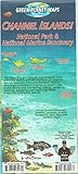
 Channel Islands National Park & Marine Sanctuary Adventure Recreation Waterproof Map by Green Planet MapsDetailed, Waterproof, Rip-Resistant! This is a map and guidebook all-in-one -- great for divers, snorkelers, hikers, kayakers and boaters. Side one is an overview map with descriptions of each island. Dozens of reef creatures and beautifully illustrated for easy identification. Side two has beautifu...$7.00$8.99
 -
Sale
 Backroads & Byways of Chesapeake Bay: Drives, Day Trips & Weekend Excursions (Backroads & Byways)This brand-new book is perfect for lighthouse enthusiasts, dolphin lovers, history buffs, art admirers, bargain shoppers―everyone! Want to hunt shipwrecks for treasure? Explore War of 1812 sites? How about visiting a waterfront village to enjoy great seafood? Or birding in a bird-watching mecca? Bac...$13.18$19.95
 -
Sale
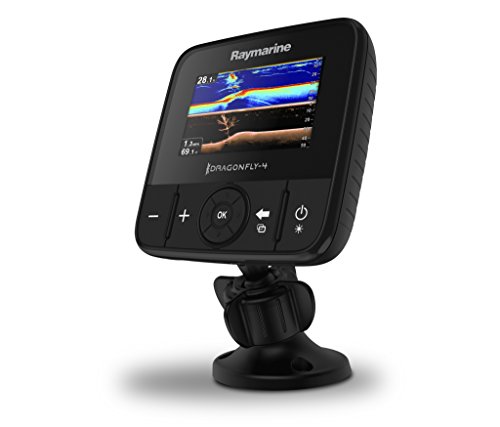 Raymarine E70294-US Dragonfly-4 Pro Sonar/GPS with US C-Map EssentialsRaymarine Dragonfly 4 Pro -US. 4" CHIRP Sonar/GPS Combo with DownVision plus conventional sonar. Wi-Fi built in. Includes C-MAP Essentials maps of US lakes, rivers and coast lines Dragonfly Pro combines GPS navigation with Raymarine's advanced dual-channel CHIRP sonar. Dragonfly Pro will change your...See At Checkout$299.99
 -
Sale
 Moon Olympic Peninsula (Moon Handbooks)Author and Washington native Jeff Burlingame knows the best ways to enjoy the Olympic Peninsula, from strolling through the subalpine meadows and temperate rain forests of Olympic National Park to soaking and swimming at Sol Duc Hot Springs. Burlingame offers unique strategies so travelers can organ...$9.20$16.99
 -
Sale
 The Cruising Guide to the Southern Leeward IslandsThis 14th edition (2016-2017) has been split into two guides, The Cruising Guide to the Northern Leeward Islands and The Cruising Guide to the Southern Leeward Islands. The Cruising Guide to the Southern Leeward Islands covers the islands of Antigua, Barbuda, Guadeloupe, Marie Galante, the Saintes,...$24.05$29.95


