


-
Sale
 The Cruising Guide to the Southern Leeward IslandsThis 14th edition (2016-2017) has been split into two guides, The Cruising Guide to the Northern Leeward Islands and The Cruising Guide to the Southern Leeward Islands. The Cruising Guide to the Southern Leeward Islands covers the islands of Antigua, Barbuda, Guadeloupe, Marie Galante, the Saintes,...$24.05$29.95
 -
Sale
 Top Spot N210 South Florida Offshore Fishing MapThe Top Spot N210 South Florida Offshore Fishing Map is part of Top Spot's waterproof map series. These maps include freshwater, inshore saltwater and offshore saltwater areas. Features include detailed information and GPS coordinates are provided for fishing locations, boat ramps, marinas and other...$22.41$22.98
 -
Sale
 Radar for Mariners, Revised EditionBecome an Expert Small-Craft Radar Operator Nothing beats radar for guiding your boat through the darkest night or the thickest fog. Radar enables you to plot a fix from just a single buoy or landmark, and it is the only navigation tool that tells you not just where you are, but who else or what els...$9.32$23.00
 -
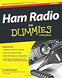
 Ham Radio For DummiesAn ideal first step for learning about ham radio Beyond operating wirelessly, today's ham radio operators can transmit data and pictures; use the Internet, laser, and microwave transmitters; and travel to places high and low to make contact. This hands-on beginner guide reflects the operational and...$28.46$24.99
 -
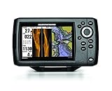
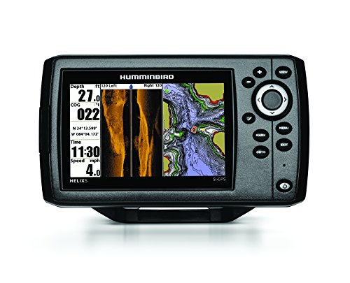 Humminbird 409640-1 HELIX 5 SI Fish Finder with Side-Imaging and GPSThe Humminbird 409640-1 HELIX 5 SI/GPS Combo features a brilliant 800H x 480V, 5" 256 color display with backlight. Side Imaging/Down Imaging and Dual Beam Plus sonar with 4000 watts PTP power output, Precision Internal GPS Chartplotting with built-in UniMap cartography with a micro SD card slot for...$552.45$499.99
 -
 Cruising the Virgin Islands Planning MapUse this map to plan your trip and for reference when in the Virgin Islands. Routes between the most popular island destinations are shown along with GPS waypoints. The back of the map includes aerial photos of the most popular harbors, coves and islands are show along with navigation guidance as an...$12.95$12.95
 -
Sale
 Standard Horizon CPN700i 7-Inch Touchscreen Network ChartplotterStandard Horizon CPN700i Touchscreen Network Chart plotter. The CPN series plotters come with built in Wi-Fi, multimedia capabilities, USB and Bluetooth technology, Ethernet networking, XM Weather overlay, and more, all on an easy-to-use touch screen display. With built-in Wi-Fi you will have full i...$1229.43$2166.65
 -
Sale
 WEEMS & PLATH Marine Navigation ParaLock PlotterWeems and Plath ParaLock Plotter 90 Weems and Plath ParaLock Plotter 90 Enables transfer of GPS positions rapidly, easily and accurately to any paper chart. New parallel rule in a compact size that is particularly suited for use on modern small chart tables. All the features of standard...$23.01$27.00
 -
 Faria 13150 Dress Depth Sounder with Transom Mounted TransducerThe Depth Sounders from Faria offer a 199 foot (61m) depth capability with an automatic gain control, backlighting for maximum night vision keel offset, and deep and shallow water alarms. Depth can be read in meters and feet. With its oversized back-lit display depth can be easily read in any condit...$96.31$96.31
 -
Sale
 Lowrance 000-12178-001 Elite-9 Fishfinder/Chartplotter with Navionics+, 50/200KHz CHIRP and 455/800KHz DownScan TransducerLowrance Elite-9 CHIRP Fishfinder/Chartplotter. 9" Widescreen Color LCD with Navionics Gold Charts for the U.S. and Canada. Includes 50/200KHz CHIRP and 455/800KHz DownScan Imaging transducer. All-NEW, easy-to-use, 9-inch fishfinder/chartplotter combines CHIRP Sonar with DownScan Imaging technology,...$1306.27$1499.00
 -
Sale
 Garmin GPS Device Belt Tape Clip For Astro ETrex Geko Gpsmap Rino Ghp 10 Series• Compatible with eTrex(R) series, Astro(R) series, Geko series, GPSMAP(R) 60 series & Rino(R) seriesLength: "Width: "Height: "$21.88$22.28
 -
Sale
 Raymarine E90W 9-Inch Waterproof Marine GPS and ChartplotterRaymarine E90W Multifunction Display US Charts$3289.50$3995.00


