


-
 Garmin GPSMAP 531s 5-Inch Waterproof Marine GPS and Chartplotter with SounderGPSMAP 531 Series GPS Receiver (GPSMAP 531S; With dual-beam transducer)$799.00$599.99
 -
 Accessory Basics MT G KIT-2 Smartphone Claw Holder With 360° Swivel Rotation & Sticky Dashboard Windshield Suction Mount for Smart Phones up to 4-Inch wideAccessoryBasics® BASICS-III Universal Smartphone Sticky Suction Mount Tired of Fumbling for Your Smartphone or GPS Device? Looking for your phone or GPS while you're driving can be a pain. Not only that, but it dramatically increases your risk of having an accident. Our BASICS-3 deluxe sticky unive...$7.95$7.95
 -
Sale
 Top Spot Map N214 Jupiter-StuartTop Spot Fishing Maps are waterproof and include freshwater, inshore saltwater and offshore saltwater areas. Detailed information and GPS coordinates are provided for fishing locations, boat ramps, marinas and other points of interest. ; Top Spot Map N-214, Florida ;Jupiter to Stuart Area - Jupiter...$22.41$22.98
 -
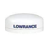
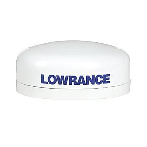 LOWRANCE LGC-16W ELITE GPS - ANTENNA WITH 20' CABLEPassive external GPS antenna with 15 ft/ cable (for Elite-5/5m)$74.84$74.84
 -
Sale
 Humminbird 409160-1 959ci HD GPS/Sonar Combo FishfinderHumminbird 959ci HD GPS/Sonar Combo with 8-Inch 480 x 800 Color VGA Display. The 959 features include Super-bright LED backlit LCD provides bright, crystal-clear images for easy viewing in harsh sunlight, DualBeam PLUS with SwitchFire sonar, 10Hz Precision internal GPS with built-in cartography: Hum...$840.00$999.99
 -
Sale
 Basic Illustrated Map and Compass (Basic Illustrated Series)BASIC ILLUSTRATED MAP AND COMPASSWilderness guide Cliff Jacobson created the map and compass curriculum for the Minnesota Department of Natural Resources, and here he shows easy-to-follow steps on choosing a compass, reading contour lines and other map features, using them in concert with a GPS rece...$8.94$12.95
 -
 WizGear Universal Air Vent Magnetic Car Mount Holder with an Extended Swivel HeadWizGear Universal Air Vent Magnetic Car Mount Holder Black Setting your phone on a mount in your car has never been easier! WizGear Air Vent Car Mount for smartphones saves you the hassle of placing your smartphone securely to make sure it doesn't fall just push it in the air vent! The WizGear Air...$7.99$7.99
 -
 Garmin GPSMAP 547 10Hz GPS/GLONASS ReceiverAn Amazing Chartplotter 5" VGA display 10 Hz GPS/GLONASS receiver Wireless connectivity U.S. coastal and inland mapping GPSMAP 547 allows for easy visibility, day or night. Whether it is flat, flush or swivel-mounted, it will be the focal point of your helm. It includes our hallmark user-friendl...$749.99$749.99
 -
 Garmin GPSMAP 431S GPS Dual Beam ComboULTRA-BRIGHT 4" DIAGONAL QVGA DISPLAY240 X 320 PIXELS MORE THAN 800 NITS OF BRIGHTNESSPRELOADED WITH CHARTS FOR MORE THAN 14000 US LAKES & NAVIGABLE RIVERSBUILT-IN HIGH-SENSITIVITY GPS RECEIVERHIGH-SPEED PROCESSOR FOR FAST SCREEN REDRAWS & SMOOTH PANNING2 NMEA 0183 I/O PORTSSTREAMLINED USER INTERFAC...$899.00$449.99
 -
Sale
 The Northern Bahamas Cruising Guide Volume 1From Grand Bahama and the Abacos South to Cat Island Completely updated 2013 Edition of the Pavlidis Bahamas Guides All Original Charts Based on Personal Surveys Conducted by the Author Extensive Navigational Instructions and GPS Waypoints New Full-color Aerial Photos and Charts Coverage Includ...$46.31$64.95
 -
Sale
 Top Spot Map N220 East FloridaTop Spot Fishing Maps are waterproof and include freshwater, inshore saltwater and offshore saltwater areas. Detailed information and GPS coordinates are provided for fishing locations, boat ramps, marinas and other points of interest. Top Spot Map N-220, Florida. Atlantic Ocean East Florida Offshor...$22.98$27.48
 -
Sale
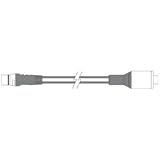
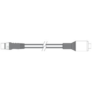 Raymarine Adapter Sea Talk-Ng to Nmea Device NetDevice net NMEA adapter cable, Mfg# A06046, adapts sea talk-ng to NMEA2000 network. For use with E & C Series widescreen, G Series, and St70 systems.$28.45$29.99


