


-
 The Best Southwest Florida Anchorages: Explore The Anchorages Of Southwest Florida -- Anchorage Charts -- GPS Coordinates -- Aerial PhotosDiscover cruising Southwest Florida, considered by many as one of the finest boating regions found anywhere and plan your cruise with this new guide to the Best Southwest Florida Anchorages. Southwest Florida cruising offers boaters the widest possible range of outstanding anchorages, marinas, dinin...$14.95$14.95
 -
Sale
 In-Fisherman Pike: Handbook of StrategiesEasy to read text, photos, in-depth charts, illustrations, and maps lead you through the seasons for consistent success in catching this legendary tackle buster.$2.90$12.95
 -
 I Shouldn't Tell You This: Trolling Tips the Pros Don't Want You to KnowAn expert guide to the most effective Trolling Tips, directly from the Ancient Mariner. This book is the first edition, jam-packed from cover to cover of time tested, tried and true trolling techniques and insights every saltwater fisherman needs to know in order to catch fish. You will learn about...$16.99
 -
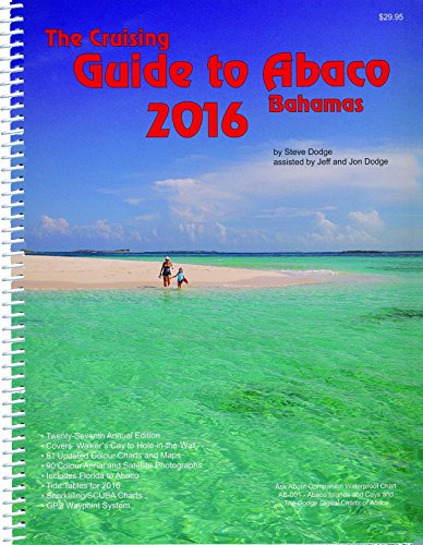 The Cruising Guide to Abaco, Bahamas: 2016This twenty-seventh edition of the only annually updated cruising guide to Abaco includes updates for 16 of the 81 navigational charts and marina maps in the book including updates and expanded information on Sand Banks and Dont Rock passage. This edition also contains new information and suggestion...$39.95$29.95
 -
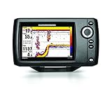
 Humminbird 409720-1 HELIX 5 PT Portable Fish Finder with GPSThe Humminbird 409720-1 HELIX 5 Portable Sonar/GPS Combo offers Dual Beam Plus Sonar and GPS chartplotting with internal GPS receiver for 2,500 waypoints, 45 routes, 50 tracks and 20,000 waypoints. Also, includes Humminbird UniMap base maps and is compatible with Humminbird LakeMaster charts, includ...$953.99
 -
 Cruising Catalina Island 2nd editionNow with 2019 mooring update, Bill McNeely's Cruising Catalina Island 2nd ed. is the authoritative boater's guide for Santa Catalina Island, CA. This is a complete re-write of the 2002 first edition, adding new coves, more photos, charts, and data, and answering all the tough questions. Covers Avalo...$32.95
 -
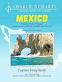
 Charlie's Charts: WESTERN COAST OF MEXICO AND BAJAThis all new edition is a totally updated cruising guide covering the entire Pacific coast of Mexico from The US Border, down the Baja Peninsula, around up into the Sea of Cortez all the way north to San Felipe, across to Puerto Penasco and south to Puerto Madero/Chiapas. There are 61 additional cha...$79.95
 -
Sale
 Island Hopping To The CaribbeanProvides advice on traveling by boat from Florida to the Caribbean by island hopping your way through the Bahamas, the Turks and Caicos Islands, the Dominican Republic, and Puerto Rico. Discusses suggested reference sources, charts, trip timing, and routes. In addition it includes a narrative of the...$16.32$17.00
 -
 C-MAP 4D Full Central America & Caribbean SD/MSD CardC-Map 4D full option, Mfg# na-d027, central America & Caribbean on SD/MSD card. Includes Vector charts, Port info, tides & currents, aerial photos, roads, elevations, perspective view. With satellite imagery, 3D viewing, and raster charts.$290.41$290.41
 -
 Waterway Guide Southern 2015 (Waterway Guide Southern Edition)Updated annually, the Waterway Guide Southern 2015 edition is the indispensable cruising companion for boaters exploring Florida's East coast, the St. John's River, the Okeechobee Waterway, the Keys, Florida's West coast and the Gulf of Mexico to Brownsville, Texas. The guide features mile-by-mile n...$175.00$39.95
 -
 Cruising Ports: the Central American Route 6.5Updated in March, 2017, this nautical guidebook (272 pages) for boaters (sail & power) covers all the marinas, anchorages & services along Pacific Guatemala, El Salvador, Nicaragua, Costa Rica, Panama - also Mexico's Gulf Coast, Yucatan Channel, NW Cuba, Belize, Rio Dulce, Honduras and Western Carib...$409.99$59.95
 -
 International Marine's Weather Predicting Simplified: How to Read Weather Charts and Satellite ImagesWeather Predicting Simplified is the first book that shows the reader, with many sample satellite photos and weather maps, how to predict the weather easily and accurately - without having to wait for hours for NOAA updates.$39.69$25.95