


-
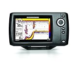
 Humminbird 409720-1 HELIX 5 PT Portable Fish Finder with GPSThe Humminbird 409720-1 HELIX 5 Portable Sonar/GPS Combo offers Dual Beam Plus Sonar and GPS chartplotting with internal GPS receiver for 2,500 waypoints, 45 routes, 50 tracks and 20,000 waypoints. Also, includes Humminbird UniMap base maps and is compatible with Humminbird LakeMaster charts, includ...$953.99
 -
Sale
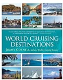
 World Cruising Destinations184 countries. Endless possibilities for the cruising vacation of your dreams "What Jimmy Cornell doesn't know about cruising isn't worth knowing."--Yachting World World Cruising Destinations is the only nautical tourist guide to the world, the ultimate aid for planning an ocean voyage or a charter...$40.00$49.95
 -
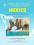
 Charlie's Charts: WESTERN COAST OF MEXICO AND BAJAThis all new edition is a totally updated cruising guide covering the entire Pacific coast of Mexico from The US Border, down the Baja Peninsula, around up into the Sea of Cortez all the way north to San Felipe, across to Puerto Penasco and south to Puerto Madero/Chiapas. There are 61 additional cha...$79.95
 -
Sale
 Great Exuma Bahamas Dive Map & Reef Creatures Guide Franko Maps Laminated Fish CardPerfect for divers, snorkelers and nature lovers! Side One is a mini-map of Great Exuma, The Bahamas, and The Exumas with dive sites named and located. Side Two is a fish identification guide with nearly 100 species illustrated. This convenient, waterproof reference is made of hard, laminated plasti...$5.69$5.99
 -
 C-MAP 4D Full Central America & Caribbean SD/MSD CardC-Map 4D full option, Mfg# na-d027, central America & Caribbean on SD/MSD card. Includes Vector charts, Port info, tides & currents, aerial photos, roads, elevations, perspective view. With satellite imagery, 3D viewing, and raster charts.$290.41$290.41
 -
 Waterway Guide Southern 2015 (Waterway Guide Southern Edition)Updated annually, the Waterway Guide Southern 2015 edition is the indispensable cruising companion for boaters exploring Florida's East coast, the St. John's River, the Okeechobee Waterway, the Keys, Florida's West coast and the Gulf of Mexico to Brownsville, Texas. The guide features mile-by-mile n...$175.00$39.95
 -
 1:24,000 Pocket Sized Slot Tool"Pocket Sized" UTM Slot Tool 1:24,000 Fast and easy UTM plotting This tool enables you to plot UTM coordinates to a 10 meter accuracy within a 1 kilometer grid square. The tool also has a compass rose along its outside edge. This makes plotting or measuring a bearing a snap. The small size of this t...$3.95$3.95
 -
Sale
 Geocaching For DummiesFind a high-tech hobby in the great outdoors! Dig into this fast-growing detective sport that's fun for all ages Once you get your coordinates, your GPS receiver, maps, compass, and this book, you're ready for adventure! Seek out containers of goodies hidden around the world by other geocachers, h...$12.00$19.99
 -
 Humminbird LakeMaster Chart - Great Plains - MicroSD/SD (56242)LakeMaster Chart - Great Plains - MicroSD/SDThe Humminbird LakeMaster Great Plains Edition, Version 5 Map Card combines many of the best fishing waters for Iowa, Illinois, Kansas, Missouri, and Nebraska all on one map card.The Great Plains Version 5 map card is i-Pilot® Link&153; compatible. Version...$238.41
 -
 International Marine's Weather Predicting Simplified: How to Read Weather Charts and Satellite ImagesWeather Predicting Simplified is the first book that shows the reader, with many sample satellite photos and weather maps, how to predict the weather easily and accurately - without having to wait for hours for NOAA updates.$39.69$25.95
 -
 Garmin International GAR0100130603 GPSmap7610xsv Combo Bluechart G2 & Lakevu HD USGarmin Part #010-01306-03Garmin Part # 010-01306-03 Gpsmap 7610XsvPackage Quantity = 1$3499.99$3499.99
 -
Sale
 Coastal NOAA Charts for Cruising Guide to Western FloridaBased on the National Oceanic and Atmospheric Administration charts, this companion to the Cruising Guide to Western Florida contains color navigational charts pertaining to the area. Not only does it give cruisers information on where to drop anchor, but also what to do once they abandon their sea...$51.21$65.00